به وبلاگ من خوش آمدید
اینجانب مقدم شما و ورود شما را به این وبلاگ خوش آمد می گویم و امیدوارم لایق وقت گرانبهای شما باشم که در گذر از این وبلاگ صرف می کنید
من قطره ای کوچک آب از خطه آذربایجان ایران هستم .گاهی که دلم گرفته میشود می خواهم که بارانی باشم ببارم بر دلها
دود اگر بالا نشیند کسر شان شعله نیست جای چشم ابرو نگیرد گرچه او بالاتر است
من از روییدن خار سر دیوار دانستم که ناکس کس نمی گردد بدین بالا نشینی ها •
پست الکترونیک
تبادل
لینک هوشمند
برای تبادل
لینک ابتدا ما
را با عنوان
sarigalin و
آدرس
rezaravan.LoxBlog.ir
لینک
نمایید سپس
مشخصات لینک
خود را در زیر
نوشته . در صورت
وجود لینک ما در
سایت شما
لینکتان به طور
خودکار در سایت
ما قرار میگیرد.
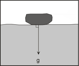
Gravity
The main force responsible for mass movement is gravity. Gravity is the force that acts everywhere on the Earth's surface, pulling everything in a direction toward the center of the Earth. On a flat surface the force of gravity acts downward. So long as the material remains on the flat surface it will not move under the force of gravity.
Of course if the material forming the flat surface becomes weak or fails, then the unsupported mass will move downward.
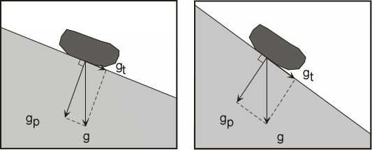
On a slope, the force of gravity can be resolved into two components: a component acting perpendicular to the slope and a component acting tangential to the slope.
The perpendicular component of gravity, gp, helps to hold the object in place on the slope. The tangential component of gravity, gt, causes a shear stress parallel to the slope that pulls the object in the down-slope direction parallel to the slope.
On a steeper slope, the shear stress or tangential component of gravity, gt, increases, and the perpendicular component of gravity, gp, decreases.
The forces resisting movement down the slope are grouped under the term shear strength which includes frictional resistance and cohesion among the particles that make up the object.
When the sheer stress becomes greater than the combination of forces holding the object on the slope, the object will move down-slope.
Alternatively, if the object consists of a collection of materials like soil, clay, sand, etc., if the shear stress becomes greater than the cohesional forces holding the particles together, the particles will separate and move or flow down-slope.
Thus, down-slope movement is favored by steeper slope angles which increase the shear stress, and anything that reduces the shear strength, such as lowering the cohesion among the particles or lowering the frictional resistance. This is often expressed as the safety factor, Fs, the ratio of shear strength to shear stress.
Fs = Shear Strength/Shear Stress
If the safety factor becomes less than 1.0, slope failure is expected.
The Role of Water
Although water is not always directly involved as the transporting medium in mass movement processes, it does play an important role.
Water becomes important for several reasons
Addition of water from rainfall or snow melt adds weight to the slope. Water can seep into the soil or rock and replace the air in the pore space or fractures. Since water is heavier than air, this increases the weight of the soil. Weight is force, and force is stress divided by area, so the stress increases and this can lead to slope instability.
Water has the ability to change the angle of repose (the slope angle which is the stable angle for the slope).
Think about building a sand castle on the beach. If the sand is totally dry, it is impossible to build a pile of sand with a steep face like a castle wall. If the sand is somewhat wet, however, one can build a vertical wall. If the sand is too wet, then it flows like a fluid and cannot remain in position as a wall.
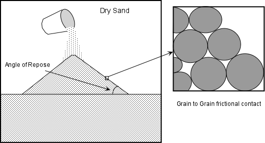
Dry unconsolidated grains will form a pile with a slope angle determined by the angle of repose. The angle of repose is the steepest angle at which a pile of unconsolidated grains remains stable, and is controlled by the frictional contact between the grains. In general, for dry materials the angle of repose increases with increasing grain size, but usually lies between about 30 and 45 o.
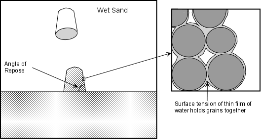
Slightly wet unconsolidated materials exhibit a very high angle of repose because surface tension between the water and the solid grains tends to hold the grains in place.
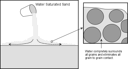
When the material becomes saturated with water, the angle of repose is reduced to very small values and the material tends to flow like a fluid. This is because the water gets between the grains and eliminates grain to grain frictional contact.
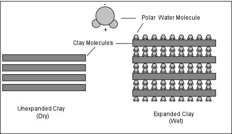
Water can be adsorbed or aborted by minerals in the soil. Adsorption, causes the electronically polar water molecule to attach itself to the surface of the minerals. Absorption causes the minerals to take the water molecules into their structure. By adding water in this fashion, the weight of the soil or rock is increased. Furthermore, if adsorption occurs then the surface frictional contact between mineral grains could be lost resulting in a loss of cohesion, thus reducing the strength of the soil.
In general, wet clays have lower strength than dry clays, and thus adsorption of water leads to reduced strength of clay-rich soils.
Water can dissolve the mineral cements that hold grains together. If the cement is made of calcite, gypsum, or halite, all of which are very soluble in water, water entering the soil can dissolve this cement and thus reduce the cohesion between the mineral grains.
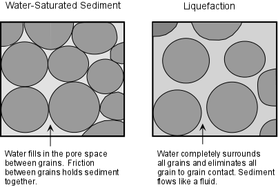
Liquefaction - As we have already discussed, liquefaction occurs when loose sediment becomes oversaturated with water and individual grains loose grain to grain contact with one another as water gets between them.
This can occur as a result of ground shaking, as we discussed during our exploration of earthquakes, or can occur as water is added as a result of heavy rainfall or melting of ice or snow. It can also occur gradually by slow infiltration of water into loose sediments and soils.
The amount of water necessary to transform the sediment or soil from a solid mass into a liquid mass varies with the type of material. Clay bearing sediments in general require more water because water is first absorbed onto the clay minerals, making them even more solid-like, then further water is needed to lift the individual grains away from each other.
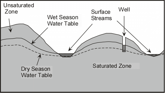
Groundwater exists nearly everywhere beneath the surface of the earth. It is water that fills the pore spaces between grains in rock or soil or fills fractures in the rock. The water table is the surface that separates the saturated zone below, wherein all pore space is filled with water from the unsaturated zone above. Changes in the level of the water table occur due changes in rainfall. The water table tends to rise during wet seasons when more water infiltrates into the system, and falls during dry seasons when less water infiltrates. Such changes in the level of the water table can have effects on the factors (1 through 5) discussed above.
Another aspect of water that affects slope stability is fluid pressure. As soil and rock get buried deeper in the earth, the grains can rearrange themselves to form a more compact structure, but the pore water is constrained to occupy the same space. This can increase the fluid pressure to a point where the water ends up supporting the weight of the overlying rock mass. When this occurs, friction is reduced, and thus the shear strength holding the material on the slope is also reduced, resulting in slope failure.
Troublesome Earth Materials
Expansive and Hydrocompacting Soils - These are soils that contain a high proportion of a type of clay mineral called smectites or montmorillinites. Such clay minerals expand when they become wet as water enters the crystal structure and increases the volume of the mineral. When such clays dry out, the loss of water causes the volume to decrease and the clays to shrink or compact (This process is referred to as hydrocompaction).
Another material that shows similar swelling and compaction as a result of addition or removal of water is peat. Peat is organic-rich material accumulated in the bottoms of swamps as decaying vegetable matter.
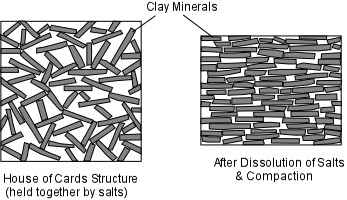
Sensitive Soils - In some soils the clay minerals are arranged in random fashion, with much pore space between the individual grains. This is often referred to as a "house of cards" structure. Often the grains are held in this position by salts (such as gypsum, calcite, or halite) precipitated in the pore space that "glue" the particles together.
As water infiltrates into the pore spaces, as discussed above, it can both be absorbed onto the clay minerals, and can dissolve away the salts holding the "house of cards" together.
Compaction of the soil or shaking of the soil can thus cause a rapid change in the structure of the material. The clay minerals will then line up with one another and the open space will be reduced.
But this may cause a loss in shear strength of the soil and result in slippage down slope or liquefaction. This is referred to as remolding. Clays that are subject to remolding are called quick clays.
Some clays, called thixotropic clays, when left undisturbed can strengthen, but when disturbed they loose their shear strength. Thus, small earthquakes or vibrations caused by humans or the wind can suddenly cause a loss of strength in such materials.
Weak Materials and Structures
Bedding Planes - These are basically planar layers of rocks upon which original deposition occurred. Since they are planar and since they may have a dip down-slope, they can form surfaces upon which sliding occurs, particularly if water can enter along the bedding plane to reduce cohesion. In the diagram below, note how the slope above the road on the left is inherently less stable than the slope above the road on the right.
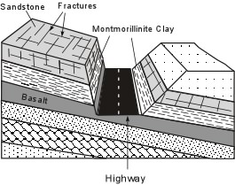
Weak Layers - Some rocks are stronger than others. In particular, clay minerals generally tend to have a low shear strength. If a weak rock or soil occurs between stronger rocks or soils, the weak layer will be the most likely place for failure to occur, especially if the layer dips in a down-slope direction as in the illustration above. Similarly, loose unconsolidated sand has no cohesive strength. A layer of such sand then becomes a weak layer in the slope.
Joints & Fractures - Joints are regularly spaced fractures or cracks in rocks that show no offset across the fracture (fractures that show an offset are called faults).
Joints form as a result of expansion due to cooling, or relief of pressure as overlying rocks are removed by erosion.
Joints form free space in rock by which water, animals, or plants can enter to reduce the cohesion of the rock.
If the joints are parallel to the slope they may become a sliding surface. Combined with joints running perpendicular to the slope (as seen in the sandstone body in the illustration above), the joint pattern results in fractures along which blocks can become loosened to slide down-slope.
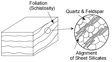
Foliation Planes - During metamorphism of rock, differential stress causes sheet silicate minerals, like clay minerals, biotite, and muscovite, to grow with their sheets parallel to one one another, This results in the rock having a foliation or schistosity Because the sheet silicates can break easily parallel to their sheet structure, the foliation or schistosity may become a slip surface, particularly if it it dips in the down-slope direction.
Triggering Events
A mass movement event can occur any time a slope becomes unstable. Sometimes, as in the case of creep or solifluction, the slope is unstable all of the time and the process is continuous. But other times, triggering events can occur that cause a sudden instability to occur. Here we discuss major triggering events, but it should be noted that it if a slope is very close to instability, only a minor event may be necessary to cause a failure and disaster. This may be something as simple as an ant removing the single grain of sand that holds the slope in place.
Shocks - A sudden shock, such as an earthquake may trigger slope instability. Minor shocks like heavy trucks rambling down the road, trees blowing in the wind, or human made explosions can also trigger mass movement events.
Examples:
Turnagain Heights Alaska, 1964
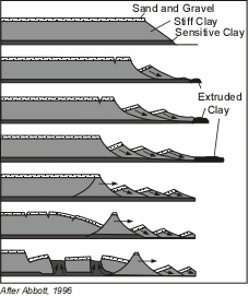
During the Good Friday earthquake on March 27, 1964, a suburb of Anchorage, Alaska, known as Turnagain Heights broke into a series of slump blocks that slid toward the ocean. This area was built on sands and gravels overlying marine clay.
The upper clay layers were relatively stiff, but the lower layers consisted of a sensitive clay, as discussed above. The slide moved about 610 m toward the ocean, breaking up into a series of blocks. It began at the sea cliffs on the ocean after about 1.5 minutes of shaking caused by the earthquake, when the lower clay layer became liquefied. As the slide moved into the ocean, clays were extruded from the toe of the slide. The blocks rotating near the front of the slide, eventually sealed off the sensitive clay layer preventing further extrusion.
This led to pull-apart basins being formed near the rear of the slide and the oozing upward of the sensitive clays into the space created by the extension. 75 homes on the top of the slide were destroyed by the movement of the mass of material toward the ocean.
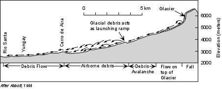
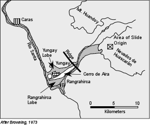
Nevados de Huascarán, Peru, 1962 and 1970.
Nevados de Huascarán is a high peak in the Peruvian Andes Mountains. The peak consists of granite with nearly vertical joints (fractures) covered by glacial ice. On January 10, 1962 a huge slab of rock and glacial ice suddenly fell, with no apparent triggering mechanism. This initiated a debris flow that moved rapidly into the valley below and killed 4,000 people in the town of Ranrahirca, but stopped when it reached the hill called Cerro de Aira, and did not reach the larger population center of Yungay.
On May 31, 1970 a magnitude 7.7 earthquake occurred on the subduction zone 135 km away from the Nevados de Huascarán.
Shaking in the area lasted for 45 seconds, and during this shaking another large block of the Nevados de Huascarán between 5,500 and 6,400 meters elevation fell from the peak.
This time it became a debris avalanche sliding across the snow covered glacier and moving down slope at velocities up to 335 km/hr. The avalanche then hit a small hill composed of glacially deposited sediment and was launched into the air as an airborne debris avalanche. From this airborne debris, blocks the size of large houses fell on real houses for another 4 km. The mass then recombined in the vicinity of Cerro de Aira and continued flowing as a debris flow, burying the town of Yungay and its 18,000 residents.
The debris flow reached the valley of the Rio Santa and climbed up the valley walls killing another 600 people on the opposite side of the river. Since then, the valley has been repopulated, and currently large cracks are seen on the remains of the glacier that still covers the upper slopes of Nevados de Huascarán.
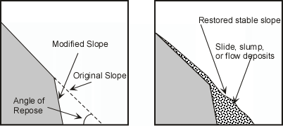
Slope Modification - Modification of a slope either by humans or by natural causes can result in changing the slope angle so that it is no longer at the angle of repose. A mass movement event can then restore the slope to its angle of repose.
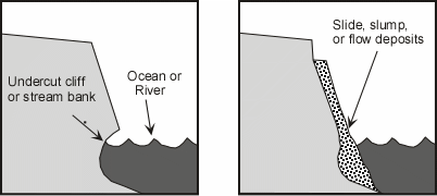
Undercutting - streams eroding their banks or surf action along a coast can undercut a slope making it unstable.
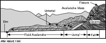
Example: Elm Switzerland, 1881
In 1870s there was a large demand for slate to make blackboards throughout Europe. To meet this demand, miners near Elm, Switzerland began digging a slate quarry at the base of a steep cliff. Slate is a metamorphic rock with an excellent planar foliation that breaks smoothly along the foliation planes. By 1876 a "v" shaped fissure formed above the cliff, about 360 meters above the quarry. By September 1881, the quarry had been excavated to where it was 180 m long and 60 m into the hill below the cliff, and the "v" shaped fissure had opened to 30 m wide.
Falling rocks were frequent in the quarry and their were almost continuous loud noises heard coming from the overhang above the quarry. Realizing that the slope had become unstable, the miners stopped working, thinking that the rock mass above the quarry would probably fall down.
On September 11, 1881 the 10 million m3 mass of rock above the quarry suddenly fell. But, it did not stop when it hit the quarry floor. Instead, it broke into pieces and rebounded into the air. Residents in Untertal, on the opposite side of the valley from the slide, saw the mass of rebounded rock coming at the them and ran uphill. But the mass of rock continued up the walls of the valley and buried them. The avalanche then turned and ran an additional 2,230 m as a dry avalanche traveling at 180 km/hr burying the village of Elm. The avalanche killed 115 people.
Changes in Hydrologic Characteristics - heavy rains can saturate regolith reducing grain to grain contact and reducing the angle of repose, thus triggering a mass movement event. Heavy rains can also saturate rock and increase its weight. Changes in the groundwater system can increase or decrease fluid pressure in rock and also trigger mass movement events.
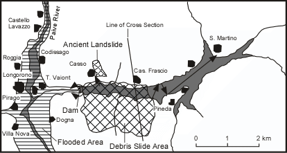
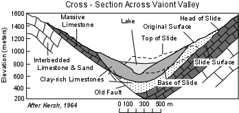
Example: Vaiont Reservoir, Italy, 1963
In 1960 a dam was built across the Vaiont Valley in northeastern Italy near the border with Austria and Slovenia. The valley runs along the bottom of a geologic structure called a syncline, wherein rocks have been folded downward and dip into the valley from both sides (see cross section below).
The rocks are mostly limestones, but some are intricately interbedded with sands and clays. These sand and clay layers form bedding planes that parallel the syncline structure, dipping steeply into the valley from both sides.
Fracture systems in the rocks run parallel to the bedding planes and perpendicular to bedding planes. The latter fractures had formed as a result of glacial erosion which had relieved pressure on the rocks that had formed deeper in the Earth.
Some of the limestone units have caverns that have been dissolved in the rock due to chemical weathering by groundwater. Furthermore, the dam site was built near an old fault system. During August and September, 1963, heavy rains drenched the area, rasing the water table and adding weight to the rocks above the dam. On October 9, 1963 at 10:41 P.M. the south wall of the valley failed and slid into the reservoir behind the dam. The slide mass was 1.8 km long and 1.6 km wide with a volume of 240 million m3. As the slide moved into the reservoir it displaced the water, forcing it 240 meters above the dam and into the village of Casso on the northern side of the valley. Subsequent waves swept up to 100 meters above the dam. Although the dam did not fail, the water rushing over the dam swept into the villages of Longorone and T. Vaiont, killing 2,000 people. Waves also swept up the reservoir where they first bounced off the northern shore, then back toward the Pineda Peninsula, and then back up the valley slamming into San Martino and killing another 1000 people. The debris slide had moved along the clay layers that parallel the bedding planes in the northern wall of the valley. A combination of factors was responsible for the slide. First filling of the reservoir had increased fluid pressure in the pore spaces and fractures of the rock. Second, the heavy rains had also increased fluid pressure and also increased the weight of the rock above the slide surface. After the slide event, parts of the reservoir were filled up to 250 m above the former water level, and even though the dam did not fail, it became totally useless. This event is often referred to as the world's worst dam disaster.
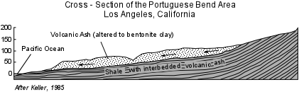
Example: Portuguese Bend, California, 1956
Portuguese Bend lies on the Palos Verdes Peninsula just to the south of Los Angeles, California, but still within Los Angeles County.
In this area the rocks have been folded into a synclinal structure with rock layers dipping gently toward the Pacific Ocean.
Rocks near the surface consist of volcanic ash that has been altered by chemical weathering to an expanding type clay called bentonite. Below these altered ash layers are shales that are interbedded with other thin volcanic ash layers that have been similarly altered to bentonite clay. The area had the appearance of an earth flow, with a very hummocky topography with many enclosed basins filled with lakes. Prior to the 1950s the area had been used for farming. In the 1950s demand for ocean views led to the development of the area as an upscale suburb. But, no sewer system was available, so wastes were put into the ground via septic tanks. In 1956 the area began moving down slope toward the ocean. Rates of movement were fastest several months after the end of the winter rainy season and slowest during the summer dry season. In the next three years the earthflow moved as much as 20 meters, but in the processes the expensive homes built on the flow became uninhabitable. Movement was caused by a combination of wave erosion along the coast removing some the mass resisting flow, added water due to the disposal of wastes, watering of lawns, and rainfall causing the bentonite clays to expand and weaken, and by the added weight of development on top of the flow. Property owners looked desperately for someone to sue, and eventually won a suit against the county of Los Angeles who had added fill dirt to build a road into the development (note that since the property owners could not sue themselves, nor could they sue the clay layers responsible for the movement they found the only agency with deep pockets that was available).
Volcanic Eruptions - produce shocks like explosions and earthquakes. They can also cause snow to melt or empty crater lakes, rapidly releasing large amounts of water that can be mixed with regolith to reduce grain to grain contact and result in debris flows, mudflows, and landslides.
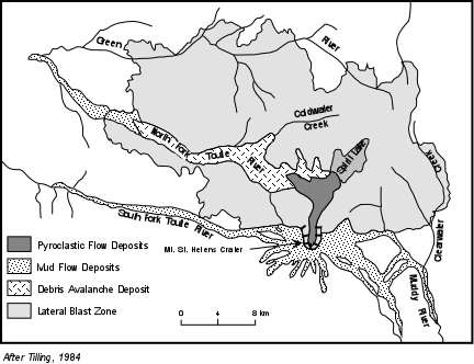
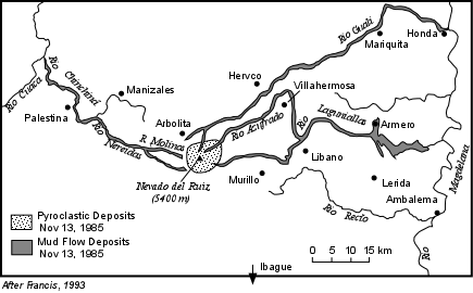
Examples - We have previously discussed the mudflows and debris avalanche produced by the 1980 eruption of Mount St. Helens, and the devastating mudflows that killed 23,000 people in Armero that resulted from an eruption of Nevado del Ruiz volcano in Columbia.
Changes in Slope Strength. Anything that acts to suddenly or gradualy change the slope strength can also be a triggering mechanism.
For example, Weathering creates weaker material, and thus leads to slope failure.
Vegetation, holds soil in place and slows the influx of water. Trees put down roots that hold the ground together and strengthen the slope.
Removal of tress and vegetation either by humans or by a forest fire, often results in slope failures in the next rainy season.
Assessing and Mitigating Mass Movement Hazards
As we have seen mass movement vents can be extremely hazardous and result in extensive loss of life and property. But, in most cases, areas that are prone to such hazards can be recognized with some geologic knowledge, slopes can be stabilized or avoided, and warning systems can be put in place that can minimize such hazards.
Hazard Assessment
If we look at the case histories of mass movement disasters discussed above, in all cases looking at the event in hindsight shows us that conditions were present that should have told us that a hazardous condition existed prior to the event.
Exploration could have revealed the sensitive clays beneath Turnagain Heights, located in known earthquake prone area. The area is now a park.
The area beneath the slopes of Nevados de Huascarán was littered with debris from prior landslide events, and even thought the first event in 1962 was not caused by an earthquake, it should have been known that the area was susceptible to such a hazard. The 1962 event should have provided fair warning to inhabitants of the area and the death and destruction caused by the 1970 event should have been avoided.
Miners in Elm, Switzerland, certainly realized that undercutting of the mountain could cause the mountain to fail, but did not consider the more widespread effect of the avalanche.
In the Portuguese Bend area, planners should have realized that the slope was an earthflow, fine for farming, but not a very desirable place to construct houses of any sort.
In both of the volcanic mudflow cases, the hazards were known before the event. In the Mount St. Helens case, hazards assessments were available and plans were in effect to minimize further damage once the event occurred. In the case of Armero, warnings were given, but ignored. The town was built on mudflow deposits from prior mudflow events.
Because there is usually evidence in the form of distinctive deposits and geologic structures left by recent mass movement events, it is possible, if resources are available, to construct maps of all areas prone to possible mass movement hazards. See the USGS Landslide Hazards map of the U. S. - http://landslides.usgs.gov/learning/nationalmap/. More detailed state and local maps can be found and most are available on the internet.
Planners can use such hazards maps to make decisions about land use policies in such areas or, as will be discussed below, steps can be taken to stabilize slopes to attempt to prevent a disaster.
Prediction
Short-term prediction of mass movement events is somewhat more problematical. For earthquake triggered events, the same problems that are inherent in earthquake prediction are present. Slope destabilization and undercutting triggered events require the constant attention of those undertaking or observing the slopes, many of whom are not educated in the problems inherent in such processes. Mass movement hazards from volcanic eruptions can be predicted with the same degree of certainty that volcanic eruptions can be predicted, but again, the threat has to be realized and warnings need to be heeded. Hydrologic conditions such as heavy precipitation can be forecast with some certainty, and warnings can be issued to areas that might be susceptible to mass movement processes caused by such conditions. Still, it is difficult of know exactly which hill slope of the millions that exist will be vulnerable to an event triggered by heavy rainfall.
Some warning signs can be recognized individual by observations of things around you:
Springs, seeps, or saturated ground in areas that have not typically been wet before.
New cracks or unusual bulges in the ground, street pavements or sidewalks.
Soil moving away from foundations.
Ancillary structures such as decks and patios tilting and/or moving relative to the main house.
Tilting or cracking of concrete floors and foundations.
Broken water lines and other underground utilities.
Leaning telephone poles, trees, retaining walls or fences
Offset fence lines.
Sunken or down-dropped road beds.
Rapid increase in creek water levels, possibly accompanied by increased turbidity (soil content).
Sudden decrease in creek water levels though rain is still falling or just recently stopped.
Sticking doors and windows, and visible open spaces indicating jambs and frames out of plumb.
A faint rumbling sound that increases in volume is noticeable as the landslide nears.
Unusual sounds, such as trees cracking or boulders knocking together, might indicate moving debris. (from USGS Landslide Hazards - http://landslides.usgs.gov/learning/prepare/)
Prevention and Mitigation
All slopes are susceptible to mass movement hazards if a triggering event occurs. Thus, all slopes should be assessed for potential mass movement hazards. Mass movement events can sometimes be avoided by employing engineering techniques to make the slope more stable. Among them are:
Steep slopes can be covered or sprayed with concrete covered with a wire mesh to prevent rock falls.
Retaining walls could be built to stabilize a slope.
If the slope is made of highly fractured rock, rock bolts may be emplaced to hold the slope together and prevent failure.
Drainage pipes could be inserted into the slope to more easily allow water to get out and avoid increases in fluid pressure, the possibility of liquefaction, or increased weight due to the addition of water.
Oversteepened slopes could be graded or terraced to reduce the slope to the natural angle of repose.
In mountain valleys subject to mudflows, plans could be made to rapidly lower levels of water in human-made reservoirs to catch and trap the mudflows.
این صفحه آخرین به روز رسانی در تاریخ 05 - AUG - 2011
عوامل موثر بر پایداری شیبها ثقل نیروی اصلی مسئول جنبش توده ای ، گرانش است. جاذبه نیرویی است که عمل می کند در همه جا بر روی سطح زمین ، از کشیدن همه چیز را در یک مسیر به سمت مرکز زمین است. روی یک سطح صاف ، نیروی گرانش رو به پایین عمل می کند. تا زمانی که مواد باقی مانده بر روی سطح صاف حرکت تحت نیروی گرانش آن را نمی خواهد.
gravflat.GIF (3،181 بایت)
البته در صورتی که مواد تشکیل دهنده سطح صاف ضعیف می شود و یا با شکست مواجه ، پس از آن جرم نشده به سمت پایین حرکت خواهد کرد.
جزء عمل به صورت عمود بر شیب و یک جزء اقدام مماس به شیب : شیب ، نیروی جاذبه را می توان به دو بخش حل و فصل است.
gravslope.GIF (9،669 بایت)
مولفه عمود بر گرانش ، پزشک عمومی ، کمک می کند تا برای نگه داشتن جسم در جای خود در شیب است. مولفه مماسی از گرانش ، GT ، باعث می شود به موازات تنش برشی به شیب که نیش ترمزی میزند جسم در جهت موازی پایین شیب به شیب.
در شیب تندتر ، تنش برشی و یا مولفه مماسی گرانش ، GT ، افزایش می یابد ، و مولفه عمود بر گرانش ، GP ، کاهش می یابد.
نیروهای مقاومت در برابر جنبش پایین شیب تحت اصطلاح مقاومت برشی که شامل مقاومت اصطکاکی و انسجام در بین ذرات است که جسم را تشکیل می دهند گروه بندی می شوند.
هنگامی که استرس محض تبدیل می شود بیشتر از ترکیبی از نیروهای برگزاری شی بر روی شیب ، شی پایین شیب حرکت خواهد کرد.
متناوبا ، در صورتی که جسم متشکل از مجموعه ای از مواد مانند خاک ، خاک رس ، ماسه ، و غیره ، در صورتی که تنش برشی بیشتر از نیروهای cohesional برگزاری این ذرات با یکدیگر می شود ، ذرات از هم جدا و حرکت یا جریان پایین شیب.
بنابراین ، پایین شیب حرکت زاویه شیب تندتر که افزایش تنش برشی است ، و از هر چیزی است که باعث کاهش مقاومت برشی ، مانند کاهش انسجام در میان ذرات و یا کاهش مقاومت اصطکاکی طرفدار. این است که اغلب به عنوان ضریب ایمنی ، FS ، نسبت مقاومت برشی به تنش برشی بیان می شود.
FS = استحکام برشی / برش استرس
اگر ضریب ایمنی می شود کمتر از 1.0 است ، انتظار می رود شکست شیب است.
نقش آب
اگرچه آب همواره نه به طور مستقیم به عنوان واسطه حمل و نقل در پروسه جنبش تودهای درگیر ، آن چه نقش مهمی را بازی.
آب می شود مهم به چند دلیل
افزودن آب از طریق بارش باران یا ذوب شدن برف می افزاید : وزن به شیب. آب می تواند به خاک یا سنگ چکه کردن و جایگزین کردن هوا در فضای منفذ یا شکستگی. از آنجا که آب سنگین تر از هوا ، وزن خاک را افزایش می دهد. وزن زور است ، و نیروی استرس به مساحت ، بنابراین افزایش استرس و این می تواند منجر به بی ثباتی شیب شود.
آب توانایی تغییر زاویه سکون (زاویه شیب است که زاویه شیب پایدار) است.
فکر می کنم در مورد ساخت یک قلعه روی ماسه های ساحل. اگر شن و ماسه کاملا خشک است ، از آن غیر ممکن است برای ساخت یک شمع شن و ماسه با چهره تند مانند یک دیوار قلعه. اگر شن و ماسه تا حدودی مرطوب است ، با این حال ، می توان یک دیوار عمودی ساخت. اگر شن و ماسه بیش از حد مرطوب ، و سپس آن را مانند یک سیال جریان می یابد و نمی تواند در موقعیت به عنوان یک دیوار باقی می ماند.
خشک دانه unconsolidated شمع را با زاویه شیب تعیین شده توسط زاویه از سکون تشکیل می دهد. زاویه از سکون steepest زاویه که در آن توده ای از دانه های unconsolidated پایدار باقی مانده است ، و توسط تماس اصطکاکی بین دانه ها کنترل می شود. به طور کلی ، برای مواد خشک زاویه از سکون را افزایش می دهد با افزایش اندازه دانه ، اما معمولا بین 30 و 45 O. نهفته
DrySand.GIF (13،428 بایت)
مواد کمی مرطوب unconsolidated نمایشگاه زاویه بسیار بالایی از سکون به دلیل کشش سطحی بین آب و دانه های جامد تمایل برای نگهداری غلات در محل.
WetSand.GIF (15،815 بایت)
هنگامی که مواد با آب اشباع می شود ، زاویه سکون کاهش می به مقادیر بسیار کوچک و مواد تمایل به مانند یک سیال جریان است. این به این دلیل که آب می شود بین دانه ها و حذف دانه به دانه اصطکاکی تماس با است.
slurry.GIF (14،393 بایت)
آب را می توان توسط مواد معدنی در خاک جذب و یا سقط. جذب ، باعث می شود مولکول آب قطبی الکترونیکی خود را متصل به سطح از مواد معدنی است. جذب باعث می شود که مواد معدنی را به مولکول های آب به ساختار آنها است. با اضافه کردن آب در این مد ، وزن خاک یا سنگ افزایش می یابد. علاوه بر این ، اگر جذب رخ می دهد و سپس تماس با سطح اصطکاکی بین دانه های مواد معدنی می تواند از دست داده و در نتیجه از دست دادن انسجام ، در نتیجه کاهش مقاومت خاک است.
خانه پروفسور م گود ، گروه مهندسی عمران ، دانشگاه کارولینای جنوبی
وقتی جاده ها شن و ماسه ، خاک رس است بر اساس درجه زیر خاک رس ساخته شده است ، زهکشی مناسب یکی از ضروری ترین کارهایی است ، مگر آن که درجه زیر جاده ، خشک و سفت مسطحسازی از شن و ماسه ، خاک رس ، مطمئن است در جهت شکستن است. معمول خندق های جانبی ، که باید به اندازه کافی بزرگ برای حمل کردن تمام از آب در حال سقوط در جاده ها ، کافی خواهد بود. این خندق طرف باید به عرض و کم عمق ، به جای تنگ و عمیق ، به این ترتیب آنها نمی خواهد سخت است نگه داشتن باز و نه خطرناک است به سفر. آنها باید از چهار تا پنج متر عرض و از یک تا یک و نیم متر عمق ، شیب دار سه تا یکی در سمت در کنار جاده و در پایین به یکی در طرف بیرونی ، و آنها باید رسانه ها به عنوان غالبا به عنوان امکان پذیر است حمل آب به طور کامل دور از جاده. هنگامی که درجه زیر است خیس و یا مرطوب بیشتر از زمان است ، و یا از طریق زمین های باتلاقی ، کاشی زیر تخلیه باید گذاشته به منظور حفظ پایه و اساس از جاده های خشک و سفت است. این را باید در ذهن منتقله که مراقبت بیشتری باید اعمال برای حفظ خاک رس با درجه زیر خشک و در اکثر موارد از زیر کلاس در خاک شنی است. آماده سازی زیر درجه
کف جاده باید درست باشد به خطوط و کلاس های ایجاد شده توسط مهندس مدرج. بنابراین تمام مواد اسفنجی ، ماده گیاهی ، درختان ، ریشه ها و stumps باید به دقت از زیر سازی راه برداشته شده است ، و فضای با مواد صدا پر شده و سطح کف جاده باید خشک و ماسه و خاک رس را باید شخم زده و harrowed با جریحه دار کردن دیسک به عمق چهار اینچ تا خاک رس به طور کامل ساییده است ، و خاک رس با درجه زیر باید نسبتا خشک ، یا آن را نمی خواهد ساییدن. بعد از این انجام شده است کف جاده باید وارد ، و آن را پس از آن آماده خواهد شد برای شن و ماسه. مخلوط کردن شن و ماسه و رس
زیر کلاس در حال حاضر با شش تا هشت اینچ از شن و ماسه تمیز و تیز و صدا پوشانده شده است. (هنگامی که خاک رس در حال حاضر شامل شن و ماسه مقدار ، مقدار شن و ماسه در بالا ذکر شد باید که بسیار بریده شده است.) شن و ماسه به طور مساوی پخش شود و از ضخامت یکنواخت است. برای به دست آوردن بهترین نتایج کف جاده باید خشک شن و ماسه اضافه شده ، و به خصوص باید آن را خشک زمانی که ماسه و خاک رس مخلوط است ، به عنوان آن بسیار دشوار است به مخلوط شن و ماسه به طور مساوی با گل رس زمانی که دومی مرطوب و چسبناک است . اختلاط در حال حاضر با جریحه دار کردن سنبله یا بهار دندان انجام شده تا شن و ماسه و خاک رس ، کاملا به ثبت رسیده و مخلوط به حالت زیر تقسیم خوب به ارمغان آورده است. جاده در حال حاضر با دستگاه جاده (کشیدن انشعاب وارد شوید ممکن است مورد استفاده قرار گیرد) ، تاج که حداقل یک نیم اینچ در هر پا از نیمی از عرض جاده را شکل داده اند ، و پرتاب به ترافیک باز است. از هم اکنون تا زمانی که سطح کاملا تثبیت می شود بزرگترین مراقبت باید ورزش را به نگه داشتن سطح صاف و مناسب تاج و سطح جاده ، برای حداقل یک هفته باید هر روز صبح با ماشین راه شکل ، اگر جاده پوشیده شده است به ruts در ابتدا یک ماده سخت است تا بدست آوردن یک سطح صاف است. در ابتدا جاده گل آلود و چسبنده بعد از هر باران ، اما این نتیجه طبیعی است [تا شن و ماسه و خاک رس] کاملا تثبیت شود. اگر بیش از خاک رس به سطح کار می کنند و باعث می شود جاده چسبناک ، شن و ماسه بیشتری باید اضافه شود تا مشکل متوقف است. از سوی دیگر ، اگر سواره رو بیش از حد شنی ، بهتر است آن را چه رسد که این مشکل به خودی خود تنظیم خواهد کرد. آبپاش و نورد
[اگر] آن مورد نظر است برای یکپارچه کردن سطح در یک بار ، به محض به عنوان ماسه و خاک رس ، کاملا مخلوط ، وسط خیابان باید پاشیده و harrowed تا شن و ماسه و خاک رس به گل قوام همگن کار کرده است. به محض این که آن را تا به اندازه کافی از خشک ، سطح باید با دستگاه جاده صاف شده و با توجه به تاج مناسب است. و درست قبل از آن به طور کامل خشک می شود باید آن را نورد تا آن سخت می شود و برای نشان دادن آهنگ های وسایل نقلیه عادی لود متوقف است. غلتک باید از شش تا ده تن وزن ، هرگز بیشتر ، و ممکن است به صورت اسب قدرت و یا غلتک بخار. نگهداری
تعمیر و نگهداری از جاده ها شن و ماسه ، خاک رس بسیار ساده و آسان است ، اگر به درستی و به طور مداوم به حضور است. سطح صاف و یکدست ، و آزاد از تمام سوراخ ها و افسردگی ها ، و ruts و عرضی تخلیه باید نگه داشته شود. این ضروری است برای جلوگیری از دوره به خوبی تعریف شده آب ، حتی آنها را کوچک ، از شکل گیری در سطح خاک رس ماسه و مخلوط شن و ماسه ، خاک رس است peculiarly منوط به اقدام های مخرب در حال اجرا آب. پس از هر باران ، و یا حداقل یک بار در هر ماه بلافاصله پس از بارش باران ، سطح جاده را باید با کشیدن دو وارد شوید و یا برخی از دستگاه های مشابه کشیده تا زمانی که سطح صاف و تاج ترمیم شده است. هنگامی که سطح بسیار خشن است و یا بد فرسوده می شود بهتر است آن را شخم زدن و نرم کردن مواد با جریحه دار کردن ، و پس از آن سطح است که به شکل و تثبیت همانطور که در مورد یک جاده جدید است. هر گاه سطح بسیار خشن است و یا بد فرسوده می شود بهتر است آن را شخم زدن و نرم کردن مواد با جریحه دار کردن ، و پس از آن سطح است که به شکل و تثبیت همانطور که در مورد یک جاده جدید است. هر گاه شن و ماسه ، خاک رس پوشیده شده است بیش از حد نازک ، مواد مسطحسازی جدید باید اضافه شود قبل از سواره رو شخم زده و harrowed ؛ در غیر این صورت مواد قدیم و جدید را ترکیب کند یا چوب با هم ، و مسطحسازی جدید در مقیاس خاموش و به زودی به هدر رفته است.
خندق های جانبی باید با توجه به نظافت عمومی و تعمیر حداقل یک بار در اوایل بهار و یک بار در اوایل پاییز است. تمام زباله و انسداد دیگر باید در طرف مقابل از جاده پرتاب و تمام اماکن scoured و سوراخ هایی در خندق باید با سنگ بصورتی پایدار و محکم بسته بندی شده و خاک رس پر شده است. ویژه باید مراقب بود تا دید که تمام رسانه های باز و کافی را به همه ی آب را به طور کامل به دور از مجاورت جاده. شانه ها که به صورت بین سواره رو و خندق جانبی باید حذف شود به طوری که تمام آب در حال سقوط بر روی سطح جاده می تواند در جریان یک بار به طرف خندق.
How to Build a Sand Clay Road
by Prof. M. Goode Homes, Department of Civil Engineering,
University of South Carolina
When a sand-clay road is built upon a clay sub-grade, proper drainage is one of the most essential things, for unless the sub-grade of the road is dry and firm the surfacing of sand-clay is sure to break through. Ordinarily side ditches, which must be large enough to carry off all of the water falling on the road, will be sufficient. These side ditches should be wide and shallow, rather than narrow and deep, as thus they will not be hard to keep open nor dangerous to travel. They should be from four to five feet wide and from one to one and a half feet deep, sloping three to one on the side next to the road and down to one on the outer side, and they should have outlets as frequently as possible to carry the water entirely away from the road. When the sub-grade is wet or damp most of the time, or is through swampy land, tile sub-drains should be laid in order to keep the foundation of the road dry and firm. It must be borne in mind that greater care must be exercised to keep the clay sub-grade dry and in the majority of cases of a sub-grade in sandy soil.
Preparing Sub-Grade
The roadbed should be graded true to the lines and grades established by the engineer. All spongy material, vegetable matter, trees, roots and stumps should be carefully removed from the roadbed, and the space thus filled in with sound material, and the surface of the roadbed should be dry and the sand and clay should be ploughed and harrowed with a disc harrow to a depth of four inches until the clay is completely pulverized, and the clay sub-grade should be comparatively dry, or it will not pulverize. After this has been done the roadbed should be leveled up, and it will then be ready for the sand.
Mixing Sand and Clay
The sub-grade is now covered with six to eight inches of clean, sharp and sound sand. (When the clay already contains much sand, the amount of sand stated above should be cut down by that much.) The sand should be spread evenly and be of a uniform thickness. To get the best results the roadbed should be dry when the sand is added, and especially should it be dry when the sand and clay are mixed, as it is very difficult to mix the sand evenly with the clay when the latter is wet and sticky. The mixing is now carried on with a spike or spring tooth harrow until the sand and clay are thoroughly incorporated and the mixture is brought to a state of fine sub-division. The roadway is now shaped up with road machine (a split-log drag may be used), the crown being at least one-half inch per foot of half width of the road, and thrown open to traffic. From now until the surface becomes thoroughly consolidated the greatest care should be exercised to keep the surface smooth and properly crowned, and for at least a week the surface of the roadway should be reshaped every morning with the road machine, for if the roadway is worn into ruts at first it is a hard matter to ever get a smooth surface. At first the roadway will get muddy and sticky after each rain, but this is a natural consequence [until the sand and clay] become thoroughly consolidated. If an excess of clay work to the surface and makes the roadway sticky, more sand should be added until the trouble ceases. On the other hand, if the roadway is too sandy, it is best to let it alone, as this trouble will adjust itself.
Sprinkling and Rolling
[If] it is desired to consolidate the surface at once, as soon as the sand and clay are thoroughly mixed, the roadway should be sprinkled and harrowed until the sand and clay are worked into a mud of homogeneous consistency. As soon as it has dried out sufficiently, the surface should be smoothed with the road machine and given the proper crown. And just before it becomes entirely dry it should be rolled until it becomes hard and ceases to show the tracks of ordinary loaded vehicles. The roller should weigh from six to ten tons, never more, and may be either horse power or a steam roller.
Maintenance
The maintenance of the sand-clay road is exceedingly simple and easy, if properly and consistently attended to. The surface should be kept smooth and even, and free from all holes and depressions, and ruts and transverse drains. It is imperative to prevent well defined water courses, even they be small, from forming in the sand-clay surface; for the sand-clay mixture is peculiarly subject to the destructive action of running water. After each rain, or at least once every month immediately after a rain, the surface of the road should be dragged with a split-log drag or some similar device until the surface is smooth and the crown restored. When the surface becomes very rough or badly worn it is best to plough it up and pulverize the material with a harrow, after which the surface is reshaped and consolidated as in the case of a new road. Whenever the surface becomes very rough or badly worn it is best to plough it up and pulverize the material with a harrow, after which the surface is reshaped and consolidated as in the case of a new road. Whenever the sand-clay has worn too thin, new surfacing material should be added before the roadway is ploughed and harrowed; as otherwise the old and new material will not mix or stick together, and the new surfacing will scale off and soon be wasted.
The side ditches should be given a general cleaning and repaired at least once in the early spring and once in the early fall. All trash and other obstructions should be thrown out on the sides opposite from the roadway; and all scoured places and holes in the ditches should be filled up with firmly packed rock and clay. Especial care should be taken to see that all outlets are open and ample to take all of the water entirely away from the vicinity of the road. The shoulders that form between the roadway and the side ditches should be removed so that all water falling on the surface of the road can at once flow into the side ditches.
در روزهای اخیر گزارشی تحت عنوان «تخلیه تراشه های نمک توسط مجریان سد گتوندعلیا در رودخانه کارون» منتشر شد که بازتاب وسیعی در رسانه های کشور پیدا کرد و پیرو آن، برخی نمایندگان مجلس از خطر شوری آب کارون ابراز نگرانی کردند.
ایبنانیوز: پس از آنکه شتابزدگی برخی مدیران محلی استان خوزستان در افتتاح فاز سوم پالایشگاه آبادان، حادثه تلخ انفجار این پالایشگاه را رقم زد و موجب کشته شدن حداقل 4 نفر از هموطنانمان گردید، پیگیریهای خبرنگار ایبنانیوز حاکی از فشارهای غیرمنطقی به مدیریت سدگتوندعلیا برای شتاب بخشیدن به افتتاحیه این پروژه ملی و آغاز آبگیری این سد با حضور رئیس جمهور می باشد و متاسفانه استاندار خوزستان بعنوان نماینده رئیس جمهور در استان نیز با چشم پوشی از نواقص این پروژه عظیم ملی، به سوی کلید زدن حادثه ای دیگر قدم بر می دارد.
در روزهای اخیر گزارشی تحت عنوان «تخلیه تراشه های نمک توسط مجریان سد گتوندعلیا در رودخانه کارون» منتشر شد که بازتاب وسیعی در رسانه های کشور پیدا کرد و پیرو آن، برخی نمایندگان مجلس از خطر شوری آب کارون ابراز نگرانی کردند.
به فاصله ی چند روز و در حالیکه هنوز سرنوشت سازندهای نمکی کناره رودخانه کارون مشخص نشده و نگرانی های فراوانی در این حوزه وجود دارد، سیدجعفر حجازی استاندار خوزستان با حضور در شوی تبلیغاتی شرکت مجری طرح، از سلامت این پروژه خبر داد و به این ترتیب، آبگیری سد گتوند علیا – که پیش از این به علت ابراز نگرانی شدید فعالان محیط زیست به تعویق افتاده بود – بصورت بی سر و صدا آغاز شد.
استاندار خوزستان درباره نگرانی ها از شوری آب کارون پس از آبگیری سد گتوندعلیا تاکید کرده بود: «در این رابطه حتی اقدامات نظارتی و نکات احتیاطی بسیار ریز در نظرگرفته شده تا این طرح برای بیش از ۱۰۰ سال آینده نیز با مشکل خاصی مواجه نشود»!
رضازاده مدیرعامل شرکت توسعه منابع آب و نیروی ایران هم، دغدغه های فعالان محیط زیست را با عنوان تحقیرآمیز «اعلام نگرانی برخی محافل» تعبیر کرد و گفت: «ما با یک ضریب اطمینان بالاتر از حد لازم فعالیت های کنترلی را با ایجاد پوششی روی این سازند و نیز با پر نمودن حفره هایی که حتی فاصله زیادی هم از مخزن دارند، انجام می دهیم. همچنین دستگاه های ویژه ای نیز برای پایش کیفیت آب در طول دوران آبگیری در نظر گرفته شده تا با کنترل های لازم این سد بزرگ بدون مشکل خاصی آبگیری شود».
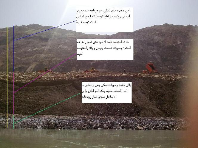
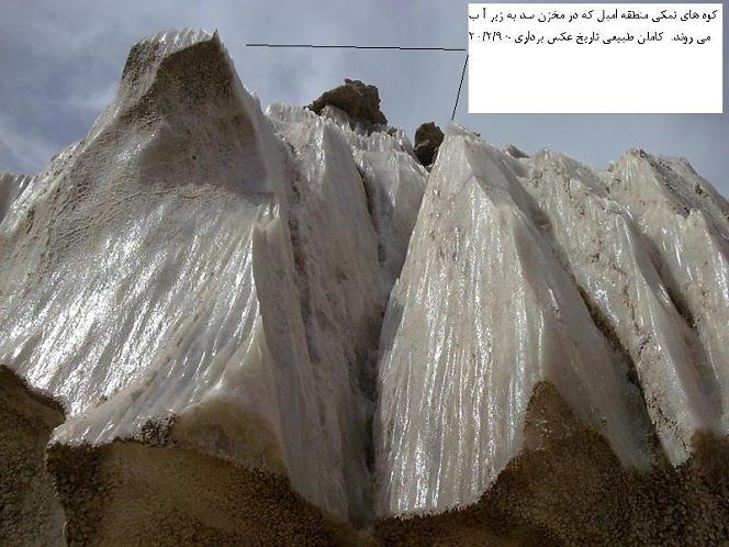
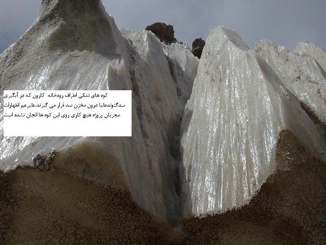
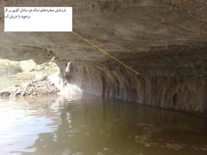
این در حالی است که وجود کوه های نمکی (تصاویر شماره۶و۴و۷و۱۶و۱۸) در مخزن سد «گتوندعلیا» موضوعی است که نزدیک به چهار سال تلاش گروه های مردم نهاد و فعالین اجتماعی استان خوزستان را به خود معطوف کرده است ولی مدیران این پروژه به جای چاره اندیشی مناسب در پی تصحیح اشتباه فاحش وزارت نیرو در جانمایی این سد یا راهکارهای دیگر نظیر تقلیل ارتفاع سد، جابجایی، یا عایق کردن کوه های نمکی برنیامدند و به این ترتیب، امروز نگرانی های گسترده ای دست به گریبان بزرگترین پروژه ی ملی کشور است و ای کاش چنین نبود و به حق می توانستیم کار عظیمی که در ساخت نیروگاه، تونل های انحراف آب و بدنه ی آن انجام شده را یک افتخار ملی بنامیم.
در چند روز گذشته پس از درج دوباره خبر وجود کوه های نمکی در حاشیه کارون، از مدیران پروژه انتظار می رفت عملکرد یک پیمانکار در تخلیه تراشه های نمک در رودخانه کارون (تصویر شماره 10 و 20) را خطای سهوی بنامند و درصدد جبران آن برآیند ولی مدیران این شرکت دولتی، جوابیه ای منتشر کردند که ضمن دفاع از عملکرد مجریان پروژه، به انکار حقایق و فرافکنی مشکل شوری آب کارون پرداخته بود.
در این جوابیه «شور شدن آب شرب روستاهای عقیلی و گتوند» که همه اهالی به آن اذعان داشته و در مطبوعات محلی استان خوزستان انعکاس برجسته ای داشته است، تکذیب شده است! در بخشی از این جوابیه، «شوری آب کارون در عقیلی و گتوند» ناشی از ورود رودخانه های محلی از جمله «شور دشت بزرگ» خوانده شده است. در حالیکه هرکس اندک آشنایی با منطقه داشته باشد می داند که رودخانه «شور دشت بزرگ» در ۲۰ کیلومتری پایین دست محل احداث سد گتوندعلیا به سمت جنوب کارون قرار دارد و هیچ گونه تاثیری بر شوری آب گتوند نمی تواند داشته باشد!
در بخش دیگری از جوابیه، وجود کوه های نمکی عظیم در مخزن سد انکار شده و با اعلام خبر «پوشش رخنمون های نمکی توسط دیواره های بتنی»، ادعای «مهار گنبد نمکی» مطرح شده است.
اقدام این شرکت دولتی در فرافکنی وجود توده های بزرگ نمک در مخزن سد گتوندعلیا، آژانس خبری بختیاری (ایبنانیوز) را بر آن داشت تا به انتشار تصاویری از این پروژه و آنچه به عنوان «مهار گنبد نمکی» نامیده شده است، بپردازد. (تصاویر شماره۵و۸) مهاری که همانگونه که در گوشه سمت چپ تصویر شماره۸ به چشم می خورد، غیر اصولی و از هم اکنون موجب بیرون زدن لایه های نمک از آن شده است.
برخلاف آنچه مدیران پروژه تحت عنوان «مهار گنبد نمکی» مطرح می کنند، تنها بر روی یک سوم کوه های نمکی «پوششی از لاشه های سنگ» قرار گرفته که این پوشش هیچ تضمینی برای عدم انحلال این توده های نمکی در آب دریاچه سد را به دست نمی دهد. ارتفاع گرفتن آب پشت سد، کوه های نمکی را در خود غوطه ور خواهد نمود و به میزان ارتفاعی که دریاچه پیدا می کند، سطح تماس آب رودخانه با کوه های نمکی بیشتر و در نتیجه شوری آب بالاتر خواهد رفت. همانگونه که در تصاویر مشهود است کارهای انجام شده تنها قسمت کوچکی از ارتفاع این «رخنمون ها» را خواهد پوشاند و معلوم نیست مابقی ۱۸۲ متر ارتفاعی که دیواره سد گتوند علیا را به دریاچه ای مهیب بدل می کند، چگونه قرار است پوشیده شود.
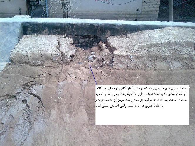
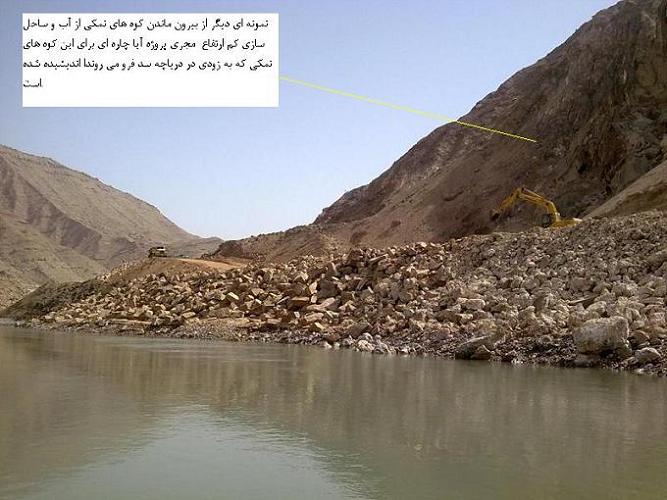
تصاویر پیوستی این گزارش که ظرف چند روز گذشته تهیه شده است به خوبی بیانگر تخلیه نمک در کارون (تصویر شماره 10 و 20 و و 11 ) و وجود کوه های نمک بدون هیچ پوشش در مخزن سد و آغاز آبگیری غیررسمی و بی سر و صدای سدگتوندعلیا است که قضاوت درخصوص آن تنها زمانی میسر است که یک گروه حقیقت یاب زیست محیطی بتواند نسبت به آن اظهارنظر کند. (تصاویر شمار۱۳و۱۴)
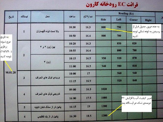
درخصوص ادعای این شرکت دولتی مبنی بر «بی تاثیر بودن سازند نمکی گچساران بر آب رودخانه کارون در محدوده سد گتوند علیا»، تصویر تابلوی EC آب رودخانه به خوبی بیانگر واقعیات این پروژه و تاثیر آن بر شوری کارون است؛ در عکس شماره 1 به تاریخ ۲۸/۲/۹۰ که در سمت راست تابلو درج شده و همچنین میزان EC آب قبل و بعد از تماس توده های نمکی توجه کنید. (این عکس ها نمایانگر EC محاسبه شده توسط مهندسان سد است که توسط خبرنگار ایبنانیوز عکس برداری شده است).
در این میان، شاید انتظاری از مدیران شرکت دولتی آب و نیرو نمی رود و طبیعی است که آنان بیش از آنکه به فکر محیط زیست و آب شرب مردم خوزستان باشند، به فکر پیشبرد پروژه خود هستند ولی از استاندار خوزستان (به عنوان کسی که قانوناً وظیفه نظارت بر پروژه های ملی در استان را برعهده دارد) انتظار می رود در باره عکس های مندرج در گزارش ایبنانیوز پاسخ دهد. به ویژه که ایشان پس از بازدید از این پروژه نه تنها مشکلات را نادیده می گیرد بلکه در یک شوی تبلیغاتی تمام عیار ادعا می کند «آبگیری سد گتوند علیا موجب افزایش کیفیت آب کارون خواهد شد». آیا مجریان پروژه، استاندار محترم را در جریان بازدید هفته گذشته، به جای دیگری غیر از محل سازندهای نمکی راهنمایی کرده اند تا ایشان حقایق را نبینند؟
اگرچه اظهارنظرهای عجیب آقای استاندار که «آبگیری سد گتوند نه تنها مشکلی ایجاد نمی کند بلکه کیفیت آب شرب اهالی پائین دست خوزستان را بالا می برد» و اینکه «تا یکصد سال آینده هیچ مشکلی در این پروژه نخواهد بود»، نزد آگاهان بعنوان یک «شوی تبلیغات سیاسی» تلقی می شود ولی بطور همزمان نشانه ضعف نظارت وی نیز قلمداد می گردد؛ زیرا ایشان طی سالهای گذشته با غافل شدن از وظایف اصلی خود در استان نظیر نظارت بر ابعاد فنی و اجتماعی پروژه های ملی، بیشتر وقت خود را صرف امور شخصی و سلیقه ای همچون دخالت در امور شوراهای اسلامی شهر و روستا و تشکیل اتاق بحران به منظور به بن بست کشاندن، بی اثر نمودن و برخورد بی سابقه با اعضای شوراهای شهر اهواز، آبادان، خرمشهر و ایذه و... نموده است که نمایندگان آن اصلی ترین منتقدان مدیریت ضعیف استاندار و فجایعی نظیر ضعف نظارتی مفرط در پروژه های عمرانی استان بوده اند.
در سالی که به نام جهاد اقتصادی مزین شده است آیا اصرار لجوجانه مسئولین شرکت آب و نیرو به خسارت چند میلیون دلاری به اقتصاد کشور منجر خواهد شد؟ آیا کوه های نمکی به زیر آب می روند و عمر سدگتوندعلیا که طولانی ترین زمان احداث یک پروژه را به خود اختصاص داده است، به دلیل فرسایش بیش از حد خاک و رسوب گذاری شدید، به کوتاه ترین عمر مفید یک پروژه بدل خواهد شد؟ آیا تاسیسات گرانقیمت مولد برق بر اثر آب شور کارون دچارخوردگی فلزات خواهند شد و سرمایه ی عظیم بیت المال به هدر خواهد رفت؟ آیا تعجیل غیرفنی در آبگیری سد گتوند علیا - قبل از آنکه گنبدهای عظیم نمک به خوبی مهار شوند - فاجعه ای شبیه انفجار پالایشگاه آبادان را رقم نخواهد زد؟
ایمنی در صنعت ساخت و ساز با زیاد شدن جوامع بشری و ایجاد ساختمانها و برجهای بلند و آسمانخراشها درمناطق مرتفع و تحولات شگرد در صنعت ساخت و ساز، تکامل و پیشرف دراین صنعت بوجود آمده و همچنین رشد روزافزون و سریع تکنولوژی، ارایه و ابداع روشهای جدید در صنایع میتوان از تحدید خطرات و حوادث طبیعی گوناگون در محیط فعالیت زندگی ما (محیط کار، منازل و ...) بطور کلی در همهجا جلوگیری کنیم. خطراتی که بر اثر ساخت و ساز درمناطق مرتفع ساختمانها راتحدید میکند مهندسان و کارفرمایان را متوجه این حوادث و صدمات کرده که با هماهنگی متخصصان روبه کاهش است. این واقعیت را نمایانگر میسازیم که نیاز شدید و اصولی به فراگیری و رعایت کامل ایمنی و حفظ ساختمانها در مناطق مرتفع را داریم تا خود و دیگران را در برابر این همه خطرات و سوانح طبیعی حفظ کنیم واین معلومات و راه و روش صحیح برای پیشگیری و چارهاندیشی را فرا گیریم که از این حوادث طبیعی (صاعقه) جان سالم بدر ببریم. صاعقه چیست و چگونه بوجود میآید؟ صاعقه یکی از اصرارآمیزترین پدیدههای خلقت است که در عین زیبایی بسیار مخرب بوده و در طول تاریخ زندگی انسان، موجب ضرر و زیان مالی و جانی بسیاری شده است صاعقه از تخلیه الکترواستاتیکی میان ابر و زمین بوجود میآید. در ابرهایی از نوع کومولونیمبوس (که گاه تا 18 کیلومتر ارتفاع و چندین کیلومتر عرض دارند) طی مراحلی ذرات آب دارای بار منفی و ذرات یخ دارای بار مثبت شده بطوری که (عموماً) بارهای منفی در لایههای زیرین و بارهای مثبت در بخشهای فوقانی ابر متمرکز میشوند. در این حالت بارهای مثبت سطح زمین نیز، در زیر سایه ابر مجتمع میشوند.
با افزایش پتانسیل الکتریکی ابر نسبت به زمین، یک جریان پیشرو از الکترونها با حرکتی نردبانی شکل از ابر به سوی زمین (downward leader) سرازیر شده و کانال اولیه صاعقه را شکل میدهد. هوای اطراف این کانال کاملاً یونیزه است این پلکان که گاه طول شاخههای آن به 50 متر میرسد، بار زیادی را در نوک پلیکان با خود حمل کرده و موجب افزایش شدت میدان الکتریکی جو وشکست مقاومت عایقی هوا میشود. در این حالت سرعت حرکت کانال نزدیک شونده به زمین بیش از 300km/s است. در این زمان با افزایش شدت میدان الکتریکی در سطح زمین، یک جریان الکتریکی بالارونده (upward leader) نیز از زمین به سوی ابر پیش میرود پس از اصابت این دو پلیکان به یکدیگر، کانال جریان بسته شده و ضربه اصلی صاعقه (retum stroke) اتفاق میافتد و بدین ترتیب جهت خنثی بارهای ابر و زمین، جریان بسیار زیادی در مدت کوتاهی در این کانال برقرار میشود. صاعقه در انواع مختلف اتفاق میافتد که متداولترین آنها (90 درصد) از نوع صاعقه منفی نزولی و خطرناکترین آنها نوع مثبت صعودی است.
صدمات اصولاً بشر تا قبل از تجربه شخصی حدود سانحه، کمتر به دنبال علت وقوع آنها بوده است اما خسارات زیاد و مکرر از اثرات اولیه (ضربههای مستقیم) و ثانویه (میدانهای الکترومغناطیسی) صاعقه امروز به حدی رسیده است که توجه و راهکارهای جدی را میطلبد شاید اولین دلیل بروز این حوادث، عدم آگاهی از روشهای صحیح حفاظت است مضافاً اینکه اغلب بدلیل ادعاهای واهی برخی فروشندگان صاعقهگیر تصور میشود که داشتن یک صاعقهگیر در خارج ساختمان (که تنها از وقوع جرقه و تخریب فیزیکی ساختمان جلوگیری می کند) میتواند کلیه تجهیزات برقی و الکترونیکی داخل ساختمان رانیز حفاظت کند، در صورتی که چنین نیست.
ظرف ده سال گذشته استانداردهای جهانی به ما این امکانات را دادهاندکه طراحیهای مناسبی با رعایت اصول قوانین emc انجام دهیم. امروزه وسایل و تجهیزاتی که برای یک زندگی ساده تدارک دیده شده پر از مدارهای الکترونیکی است. وسایل خانگی، کامپیوتر، فاکس، بیسیم، تلویزیون، تلفن، شبکههای اطلاعاتی جهانی،همه و همه از مدارهای الکترونیکی ساخته شدهاند که گران بوده و تعمیرات آنها نیز آسان نیست و گاهی از خط خارج شدن آنها مصادف با خسارتهای غیرقابل جبران است.
عواملی را که میتوانند شدیداً تجهیزات نامبرده بالا یا بطور کلی هر وسیله دیگری را که مدارهای الکترونیکی در آنها به کار رفته باشد به خطر انداخته یا غیرقابل استفاده کنند، عبارتند از:
کوپلاژ مقاومتی
وقتی که صاعقه به ساختمانی ضربه میزند جریانی که به زمین تخلیه میشد پتانسیل زمین را در سیستمهای برق و دیتا، تا چند صد کیلوولت افزایش میدهد. این امر موجب میشود بخشی از جریان صاعقه از طریق هادیهای ورودی- خروجی، به ساختمانهای دیگر منتقل شود.
کوپلاژ سلفی (مغناطیسی)
عبور جریان صاعقه از یک هادی و یا از کانال تخلیه خود، ایجاد یک میدان مغناطیسی میکند. وقتی که خطوط میدان، هادیهایی را که تشکیل لوپ دادهاند قطع کند، در آنها ولتاژی معادل چند ده کیلوولت القاء میشود.
کوپلاژ خازنی (الکتریکی)
کانال صاعقه در نزدیکی نقطه تخلیه، یک میدان شدید الکتریکی ایجاد میکند. کابلها و هادیها مانند خازن و هوا نیز عایق دیالکتریک آنهاست. بدین صورت علیرغم عدم برخورد صاعقه به ساختمان کابلها تحت یک ولتاژ بالا قرار میگیرند.
اصول حفاظت از صاعقه
حفاظت یک ساختمان بطور کامل شامل موارد زیر میشود:
حفاظت جلد خارجی ساختمان از ضربههای مستقیم صاعقه.
حفاظت داخلی و تجهیزات نصب شده در ساختمان در مقابل آثار ثانویه صاعقه
الف- حفاظت جلد خارجی ساختمان
منظور از حفاظت خارجی، حفظ بدنه و استراکچر ساختمان از آتشسوزی و انهدام در اثر اصابت صاعقه است. کلیه تجهیزاتی که جهت جذب وهدایت صاعقه از پشت بام تا شبکه زمین نصب میشوند طبق استاندارد BS6651, NFC17-102, NFC17-100, DINVDEO185 و NFPA780 و IEC61024 شناسایی میشود.
ب- حفاظت تجهیزات نصب شده در داخل ساختمان
توسعه کاربرد سیستمهای الکترونیکی درجهان، موجب افزایش شدید آمار صدمات وارده به این دستگاهها در اثر صاعقه و اضافه ولتاژهای ناشی از آن شده است. لازم به ذکر است که تنها بخشی از اضافه ولتاژها در اثر صاعقه بوده و بخش عمده آنها ناشی از عملیات سوئیچینگ و حوادث تغذیه است. برای این بخش از حفاظت، کاهش اثر میدانهای الکترومغناطیسی ناشی از صاعقه، مدنظر قرار میگیرد.
پس از برخورد صاعقه به زمین یا ساختمان، وسایل الکترونیکی داخل ساختمانهایی که شعاع 1/5 کیلومتری از محل برخورد و در محدوده میدان الکترومغناطیسی ایجاد شده قرار دارند در معرض خطر خواهند بود.
حفاظت موثر این تجهیزات در مقابل ولتاژهای القایی حاصله وقتی امکانپذیر است که کلیه سیستمهای حفاظت داخلی همراه با حفاظت خارجی ساختمان تماماً نصب شده باشند.
حفاظت داخلی از صاعقه عبارت است از تهیه وسایلی که به کمک آنها بتوان اثر ولتاژهای القائی حاصله از جریانهای صاعقه را، بر روی تجهیزات داخل ساختمان خنثی کرد.
برقگیر یا رسانای آذرخش
برقگیری یا رسانای آذرخش، ساختمانهای بلند را از یورش آذرخش (صاعقه) مصون میدارد. یک رسانای آذرخش ازیک نوار مسی کلفت تشکیل شده است که نوکهای فلزی تیزی دارند و در بالای بلندترین قسمت ساختمان کار گذاشته میشود. این نوار را به تیغه فلزی بزرگی که در اعماق مرطوب زمین زیر ساختمان مدفون گشته است متصل میکنند.
این رسانا مسیری را برای شارش بار الکتریکی از بالای ساختمان به زمین فراهم میکند.
نشست تدریجی بار مثبت از نوکها (تخلیه الکتریکی از نوکهای تیز بهتر انجام میشود) بسوی ابرها و شارش الکترونها از برقگیر به زمین، از انباشته شدن انبوه بار روی بلندترین بخشهای ساختمان جلوگیری میکند. اگر این تخلیه الکتریکی از نوکها و از طریق برقگیری صورت نگیرد تخلیه ناگهانی بار «آذرخش» صورت خواهد گرفت.
شارش ناگهانی و بسیار عظیم بار که آذرخش روی میدهد آن قدر انرژی دارد که میتواند خسارتهای جدی به ساختمان وارد کند.
راهنمای استفاده از LOM در شبکه زمین سطحی
- کانالی به عرض 30-20 سانتیمتر و عمق 75 سانتیمتر به طول مورد نظر حفر کنید. اگر عمق نفوذ یخزدگی خاک بیشتر از 75 سانتیمتر باشد باید کانال عمیقتر و تا زیر لایه یخزدگی حفاری شود کف کانال را به ضخامت 10 سانتیمتر از LOM مخلوط پر کنید.
- سیم یا تسمه مسی را روی این لایه بخوابانید.
- روی سیم را به ضخامت 10 سانتیمتر با مخلوط LOM بپوشانید مراقب باشید که هادی بطور کامل پوشانده شود و اگر هادی پوشانده نشد ضخامت LOM را افزایش دهید. بقیه کانال را با خاک پر کنید.
- با در نظر گرفتن حجم حفاری وشرایط فوق برای هر متر طول حداقل به سه کیسه LOM نیاز خواهد بود باتغییر ابعاد کانال یا ضخامت LOM مصرفی مقدار مورد LOM تغییر میکند.
راهنمای استفاده در نصب میله ارت (شبکه زمین عمودی) - حفرههای به قطر 15-25 سانتیمتر و به عمق 15 سانتیمتر کمتر از طول میله ارت حفر کنید.
- میله ارت را در وسط حفره طوری بکوبید که سر میله ارت 10 سانتیمتر پایینتر از لبه حفره واقع میشود.
- مخلوط LOM را پیرامون میله تخلیه کنید و این کار را تا 20 سانتیمتر پایینتر از لبه فوقاتی میله ارت ادامه دهید.
- اتصالات لازم را به میله ارت انجام دهید بعد دریچه بازدید را نصب کنید و یا حفره را کاملاً پر کنید.
- در حین پر کردن حفره ضروری است هر یک متر که با LOM پر میشود مقداری از آب داخل حفره تخلیه شود این عمل فشردگی و چسبندگی لایهها را به میله ارت افزایش میدهد.
- در این حالت برای هر متر عمق حفره بین یک تا سه کیسه LOM مورد نیاز است.
راهنمای استفاده در نصب صفحه مسی چاه ارت (شبکه زمین سنتی) - حفرهای به قطر تقریبی 50 سانتیمتر به عمق مورد نیاز حفر کنید.
سیم ارت یا تسمه مسی را حداقل در دو نقطه توسط روش cadweld به صفحه متصل کنید.
- صفحه ارت را به صورت عمودی در انتهای حفره قرار دهید.
- مخلوط lom را در داخل چاه طوری تخلیه کنید که ضمن فشردگی مناسب تا 20 سانتیمتر بالای سطح صفحه را بپوشاند.
- برای پر کردن مابقی حفره lom را به نسبت یک به سه با خاک حفره یا خاک رس مخلوط کرده و حفره را با مخلوط فوق پر کنید.
- در صورت نیاز دریچه بازدید را نصب کرده و هادی بیرون آمده از چاه را با هادی سیستم زمین متصل کنید.
- برای فشردگی بیشتر خاک اطراف هادی صفحه و کیفیت مناسبتر پس از هر متر که با مخلوط lom پر میشود مقدار مناسب آب اضافه کنید.
برای پر کردن چاه ارت با مشخصات فوق در یک متر اولیه 10 کیسه و برای هر متر بعد از آن برای مخلوط کردن با خاک حفره سه کیسه lom مورد نیاز است.
توجه 1- اگر شبکه سطحی، حفره میله یا چاه ارت در مسیر حرکت سفرههای آب زیرزمینی یا فاضلاب آب باران باشد باید کف آن توسط سیمان یا مخلوط سیمان و lom بتونه کاری شود که مخلوط حاضر توسط آب جاری شسته نشود.
توجه 2- در جایی که مقاومت مخصوص خاک (P) کمتر از m20 اهم باشد چنانچه قصد دارید lom را با خاک مخلوط و مصرف کنید مناسبترین نوع ترکیب از نظر تکنیکی و اقتصادی با نسبت حجمی به شرح زیر پیشنهاد میشود:
60 درصد خاک
30 درصد lom
10 درصد آب
برای مخلوط کردن صحیح اقلام فوق باید موارد به ترتیب زیر با هم مخلوط شوند تا بهترین نتیجه از یک مخلوط یکنواخت حاصل شود.
اول lom، دوم خاک، سوم آب
توجه 3- لطفاً عنایت فرمایید تاثیر نهایی مواد کاهنده بصورت فوری قابل حصول نیست و برای دسترسی به نتیجه قطعی باید بین یک تا شش ماه صبر و تحمل داشته باشید.
توجه 4- بازدید و تست دورهای سیستم زمین را فراموش نفرمایید نصب دریچه بازدید کار تست و بازرسی دورهای را تسهیل میکند.
توجه 5- محل اتصال الکتریکی سیستم زمین به شبکه ارت سطحی یا چاه ارت زیر زمین معمولاً به عنوان نقطه آزمایش سیستم در داخل دریچه بازدید قرار دارد محل تماس الکتریکی توسط نوار چسب عایق ضد خوردگی، خمیر هادی حفاظت شود.

 آمار
وب سایت:
آمار
وب سایت: